

On a waterfront lot, the boundary line is only part of the picture. Islamorada property survey requirements include a boundary survey showing property lines, relevant improvements, easements, and apparent use across boundaries. For a parcel with a water boundary, Fla. Admin. Code Ann. R. 5J-17.052 also requires the survey to describe the water feature and the method used to locate that boundary.
It’s natural to want a clear picture of what you’re buying, especially where a home, dock, access route, or drainage feature meets the shoreline. This guide explains survey details to look for, from plats and recorded easements to building dimensions, waterfront conditions, and drainage notes. It also distinguishes statewide boundary-survey requirements from information that may accompany Islamorada development applications, so you can better understand what each detail reveals about a property. Thank you for reading. Please get in touch with any questions or requests for clarification, and we’d be glad to provide a list of current homes on the market.
Key Takeaways
- Learn how a boundary survey documents mismatches between recorded descriptions and conditions on the ground.
- See which recorded easements, rights-of-way, and plat details can clarify access and property use.
- Understand how building placement, waterfront boundaries, and drainage features fit into property review.
- Thank you for reading. Please get in touch with any questions or requests for clarification, and ask for a list of current homes on the market.
Boundary inconsistencies and physical occupation
A boundary survey maps a parcel’s legal boundary and relevant evidence found on the ground. In Florida, the Islamorada property survey requirements for boundary work include documenting discrepancies between the survey map and the property description. Fla. Admin. Code Ann. R. 5J-17.052 sets out the statewide boundary-survey rule.
A boundary inconsistency is a difference between recorded boundary information and physical occupation. For example, a fence or driveway may appear to extend beyond a deed line. The survey should show and explain potential inconsistencies, including apparent use onto or from adjoining property. Its dimensions should make the relationship between the evidence and the boundary clear. This helps you understand what the field evidence shows without treating a fence as proof of ownership.
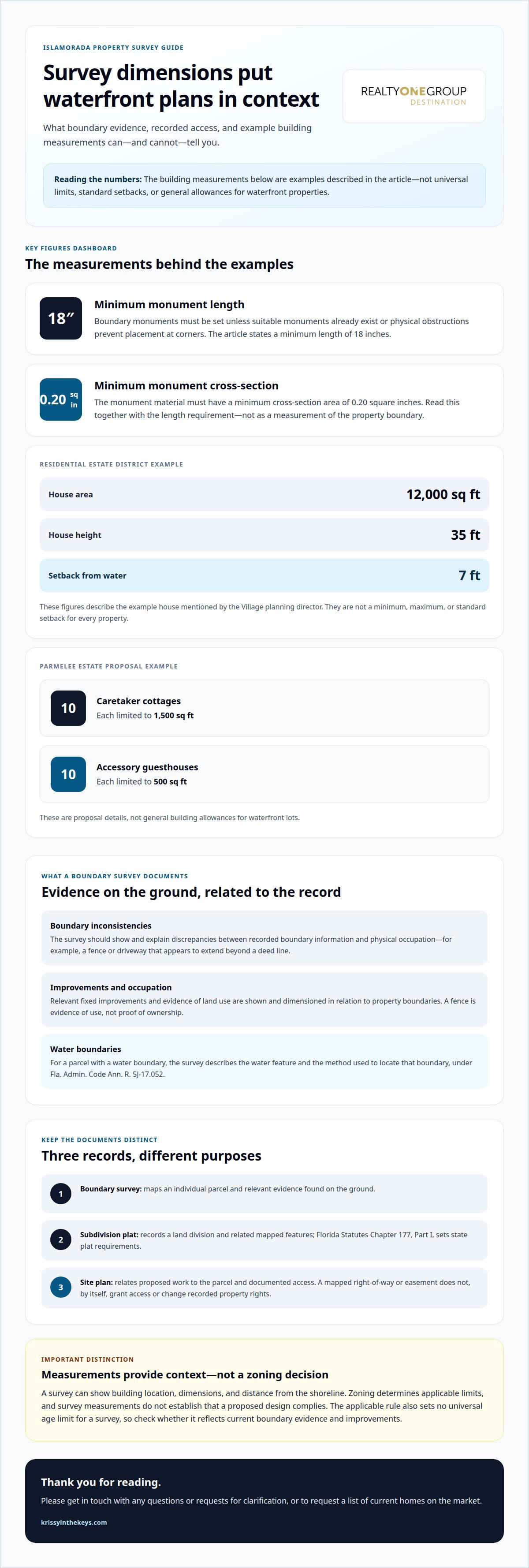
Physical occupation means visible or fixed features that show how land is being used. The survey identifies appropriate monuments and evidence of occupation, then coordinates those observations with record boundaries. Fixed improvements pertinent to the survey must be shown, with their positions dimensioned from property boundaries. Surveyors must set boundary monuments unless suitable monuments already exist or physical obstructions prevent placement at corners. Each monument must be at least 18 inches long, with a minimum cross-section area of 0.20 square inches of material.
A survey’s date alone doesn’t tell you whether it reflects current conditions. Check whether it shows current boundary evidence and improvements, since later fences, construction, or other changes may affect its usefulness. The applicable rule doesn’t set a universal age limit.
Survey fees depend on the scope of work, parcel conditions, records, and required deliverables; the surveyor provides a price after receiving a quote request. In Florida, surveyors and mappers must be licensed. To find one serving Islamorada and Monroe County, use Florida’s professional licensing records and identify coverage for the property’s location.
A survey records and measures evidence relevant to boundary conflicts, but it doesn’t decide ownership by itself. If a fence crosses the mapped line, the documented measurements can help clarify the issue as you consider your next property decision.
Plat drawing and easement requirements
A boundary survey and a subdivision plat serve different mapping purposes. Knowing which document shows an individual parcel and which records a land division helps you interpret property records more clearly.
Accepted Survey Types
A boundary survey maps an individual parcel, while a subdivision plat maps a land division. For boundary work, Florida identifies the map as a “Boundary Survey.” The requirements distinguish this survey from subdivision plats; they don’t establish one survey type for every permit application.
To identify the document relevant to your question, start with the property record involved. A parcel-boundary question relates to a boundary survey; a recorded division of lots relates to its subdivision plat. These documents provide different information, so one shouldn’t be treated as a substitute for the other.
Boundary Survey and Site Plan Details
A plat drawing presents recorded land divisions and related mapped features. Under Florida Statutes Chapter 177, Part I, subdivision plats follow the state’s plat requirements. Section 177.091(9) addresses when subdivision lot-corner monuments must be set. This provision concerns subdivision plat monumentation, rather than setting a universal review timeline for every property application.
For a site plan, compare the proposed work with the recorded plat and parcel survey to see how the layout relates to documented access. For example, a driveway shown near a recorded right-of-way deserves a close look at where the route is mapped. A drawing can clarify that spatial relationship, but it doesn’t grant access or change recorded property rights.
When reviewing a plat, distinguish a right-of-way from an easement. Either may describe a mapped access or use interest, but the recorded document provides the relevant details. Check whether the feature appears on a plat adjoining or crossing the property, then compare it with the proposed site layout. This helps keep boundary, access, and development questions separate.
Building size, height, and waterfront setbacks
A building footprint is the ground area occupied by a structure, while height measures its vertical extent. A waterfront setback is the distance between a structure and the water. A survey can show where an existing or proposed building sits in relation to parcel boundaries and the shoreline, but zoning determines the applicable limits.
Islamorada examples illustrate why dimensions matter. The Village planning director described a residential estate district house measuring 12,000 square feet and 35 feet high, with a 7-foot setback from the water. Those figures describe that example, not a minimum, maximum, or standard setback for every property. Survey measurements place structures in context; they don’t establish that a proposed design complies with zoning.
Other proposed development figures also show how building size may be documented. A Parmelee Estate proposal included 10 caretaker cottages, each limited to 1,500 square feet, and 10 accessory guesthouses, each limited to 500 square feet. These were proposal details, not general allowances for waterfront lots. A site plan can relate proposed building locations and dimensions to the parcel, helping the permitting agency assess the application against applicable zoning.
For a permit application, include the survey with the submitted site and building materials. The Village of Islamorada’s review can use the drawing to assess the building location, height information, and waterfront separation shown against the proposal and applicable zoning criteria. The available facts do not establish a specific submission channel or review sequence, so don’t assume that a survey alone secures approval.
A Florida license authorizes an individual to practise a regulated profession; surveyor and mapper licensure is separate from building approval. A surveyor and mapper business also needs a certificate of authorization. These credentials relate to who may provide surveying services, while the Village’s permit review addresses the proposed work. Survey dimensions describe the site; applicable zoning standards determine minimum setbacks and other development limits.
Drainage notes
Drainage describes how water moves across a property, while a topographic survey maps ground elevations and physical features. On an Islamorada lot, these details can help show how site conditions relate to a planned building or other construction. A survey can depict the land’s shape, while drainage notes describe how water moves across it.
For example, a low area near a proposed addition may help explain where water collects after rain. Showing it alongside the proposed layout gives a clearer picture of the site than a building footprint alone. Existing grades and proposed changes should be distinguished so the drawing doesn’t blur current conditions with planned work.
Flood-zone location alone doesn’t make an elevation certificate or topographic survey universally required under the Islamorada requirements described here. The documents serve different purposes: an elevation certificate records elevation information, while topographic mapping depicts changes in ground level. The project and permit review determine which site information is relevant. Neither document automatically approves construction.
Flood and wind rules also shape building plans in Islamorada. Most new construction requires elevated foundations, impact-rated windows, and compliance with wind and flood regulations. Survey information can place a proposed structure within the site’s physical layout, while applicable building requirements govern its design. A plan showing where a foundation sits does not, by itself, demonstrate compliance with flood requirements.
Use drainage and elevation details to understand how a proposed layout relates to the lot, rather than assuming the survey answers every construction question. A clear drawing can distinguish existing ground features from planned work and show where the proposed building sits. This context helps you discuss site conditions and applicable requirements with the appropriate department.
Krissy in the Keys (Krissy Carnahan, Realtor): Vacation Property Sales
Krissy in the Keys (Krissy Carnahan, Realtor) helps buyers and sellers connect survey findings to their next property decision through Vacation Property Sales and Luxury Waterfront Home Sales. If you’re considering a waterfront or vacation property in Islamorada, Key Largo, or Tavernier, Buyer Representation for Luxury Estates can help you assess the property and decide whether it fits your plans. Sellers can also draw on Seller Representation of Luxury Estates when preparing to bring a home to market.
Survey details can inform a purchase or sale, but they’re distinct from real estate representation. For a look at current homes and properties for sale, browse available listings.
For personalized guidance on your next property decision, contact Krissy in the Keys (Krissy Carnahan, Realtor). She can help you explore current homes on the market and consider how a property’s documented details fit your plans.
Make Your Next Property Decision With Clarity
Understanding Islamorada property survey requirements is one part of assessing how a waterfront property fits your plans. A survey can inform your questions about the parcel, but your priorities matter too: how you intend to use the home, which features are essential, and whether the property suits your next chapter. Consider those priorities alongside the documented details as you make a purchase or sale decision.
Reach out to Krissy in the Keys with any questions or requests for clarification, or to receive a list of current homes on the market. A thoughtful next step can make your search in Islamorada, Key Largo, or Tavernier feel more focused.
Thank you for considering Krissy in the Keys as you explore your options. Wishing you confidence in the decisions ahead.
Frequently Asked Questions
Does Islamorada require a property survey for building permits or renovations?
Islamorada’s requirements depend on the application and proposed work; the rules don’t establish a universal survey requirement for every permit or renovation. Development applications can require supporting documents, including vegetation surveys unless waived or limited by the Planning and Development Services Director. For a renovation that changes a building’s location or footprint, survey information can help show how the work relates to the parcel and existing improvements.
What are Islamorada's waterfront, setback, and building-envelope survey requirements?
A survey can locate a waterfront feature and show where existing or proposed structures sit relative to property boundaries. It doesn’t determine zoning limits for a building envelope or establish that a design meets a setback. For example, a planned addition may fit within the recorded parcel yet still need review against applicable zoning criteria. Treat the survey as site information, not project approval.
What are the risks of using an outdated or inaccurate survey in Islamorada?
An outdated survey may not reflect later construction, changed site features, or current evidence of how land is occupied. If a proposed project relies on old dimensions, a building or improvement could appear differently against the parcel boundary than expected. Inaccurate information can also complicate the review of access or easements. For example, a new fence or driveway missing from an earlier drawing may affect how the site is understood.
How do I submit a survey to the Islamorada Building Department, and what is the review process?
Include the survey with the submitted site and building materials. The Village of Islamorada can use it to assess the proposed building location, height information, and waterfront separation against applicable zoning criteria.
Thank you for reading. Please get in touch with any questions or requests for clarification, or to receive a list of current homes on the market.


