

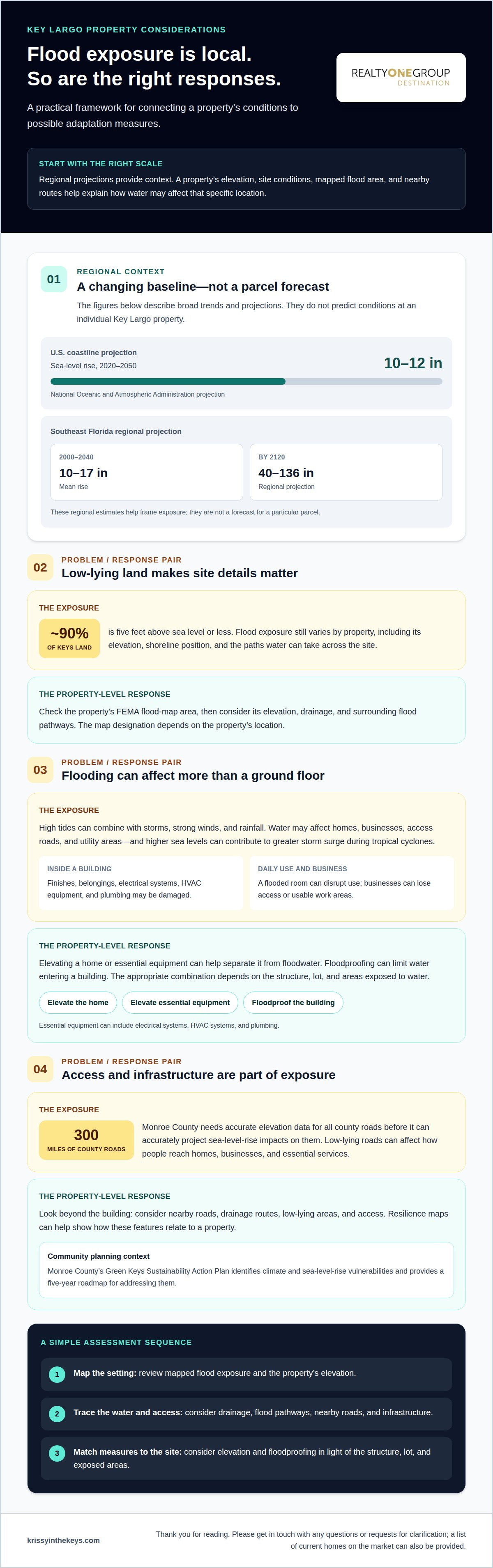
The impact of sea level rise on Key Largo property will vary with a home or business’s elevation, site conditions, and exposure to flooding. According to the National Oceanic and Atmospheric Administration, sea level along the U.S. coastline is projected to rise 10 to 12 inches between 2020 and 2050. In the Florida Keys, that makes elevation and flood exposure important parts of understanding a property.
It’s natural to wonder whether the Keys can adapt and what rising water could mean for a place you own or hope to buy. The answer involves both community planning and property-level choices. Elevation, floodproofing, and other adaptations can shape how a building responds to water, but no single measure suits every site.
This article explains how sea level rise can affect homes, businesses, and infrastructure in Key Largo, what to consider when assessing a property’s elevation and flood exposure, and how adaptation can factor into a real estate decision. You’ll gain a clearer framework for weighing these considerations alongside the waterfront lifestyle that draws people to Islamorada, Key Largo, and Tavernier.
Key Takeaways
- Understand how adaptation can involve both community planning and property-level measures, rather than a single solution for every location.
- Use a property’s elevation and site conditions to frame how exposed it may be to flooding.
- See how rising water can affect homes, businesses, and the infrastructure people rely on.
- Put local sea-level observations and projections into context when considering a Key Largo property.
Can the Florida Keys adapt to sea-level rise?
Yes. Adaptation combines community planning with measures suited to individual properties. According to the National Oceanic and Atmospheric Administration, sea level along the U.S. coastline is projected to rise 10 to 12 inches between 2020 and 2050.
Florida’s Coastal Exposure
Florida’s coastal exposure reflects how higher seas interact with storm tides, wind, and heavy rainfall. Together, these forces can bring floodwater onto roads, lots, and ground-level spaces. During tropical cyclones, higher sea levels can contribute to higher storm surge and greater coastal flooding. For property owners, exposure depends on more than distance to the shoreline. Elevation, drainage, and the routes water can take across a site also matter.
Coastal Sea Level Projections
Relative sea-level projections compare expected change with a baseline, helping put Florida trends in context. The Southeast Florida regional projection estimates 10 to 17 inches of rise from 2000 to 2040, and 40 to 136 inches by 2120. These are regional projections, not a parcel-specific forecast for Key Largo. They provide context for considering property exposure; elevation and local flood pathways help explain how water may reach a particular building.
Planning translates projections into maps, infrastructure priorities, and property decisions. Monroe County’s Green Keys Sustainability Action Plan identifies climate and sea-level-rise vulnerabilities and provides a five-year roadmap for addressing them. Resilience maps can help show how roads, drainage routes, and low-lying areas relate to a property. Buyers can get a fuller picture of potential exposure by considering access and nearby infrastructure alongside the building.
Adaptation measures can address different vulnerabilities. Elevating a home or essential equipment can help separate it from floodwater, while floodproofing can limit water entering a building. In Key Largo, the key question is which combination fits the structure, lot, and surrounding infrastructure. Regional projections inform that assessment, but cannot describe conditions at every property.
Low-lying land and property exposure in the Florida Keys
About 90% of the Florida Keys’ land mass is five feet above sea level or less. For an individual home, the FEMA flood map shows its mapped flood-risk area; the specific designation depends on its location.
Regional Sea Level Trends and Projections
Florida’s historical sea-level trend and Southeast Florida projections help frame changing coastal exposure. Sea levels across Florida are as much as 8 inches higher than in 1950. The Southeast Florida regional projection estimates 10 to 17 inches of mean rise from 2000 to 2040, and 40 to 136 inches by 2120. These regional figures provide context, while a property’s elevation and location shape its exposure.
Florida Property Losses
Projected losses illustrate the potential financial stakes of rising water across Florida. Land in the Florida Keys at risk of inundation from five feet of sea-level rise has an estimated property value of about $27 billion. Florida is projected to suffer $66 billion in losses by 2100, accounting for 20 percent of total U.S. damages. These estimates describe broad scenarios, not the value or fate of any single home.
Risks Across Florida Keys Communities
Risks vary across the Keys because elevation, shoreline position, and flood pathways differ by site. Key Largo cannot be ranked against every other community using one island-wide figure. Key West is projected to experience more than 300 tidal flooding events per year within the lifetime of today’s 30-year mortgages. For a Key Largo property, mapped flood exposure and its immediate surroundings offer more useful context than a regional comparison alone.
Key Largo Sea Level Rise and Expected Rate
The Key West gauge provides a nearby record for understanding regional change, though it is not a measurement at every Key Largo parcel. Mean sea level there rose about 3.9 inches between 2000 and 2017; sea levels are currently rising about 0.13 inches a year. The Florida Keys are projected to see 15 inches of rise by 2045. These figures help frame long-term exposure, while a FEMA map provides a property-specific view of mapped flood risk.
Impacts on homes, businesses, and infrastructure
Rising water affects more than a building’s ground floor. In Key Largo, high tides can combine with storms, strong winds, and rainfall to flood homes, businesses, access roads, and utility areas. Higher sea levels can also contribute to greater storm surge during tropical cyclones. Exposure depends on how water reaches a site and which parts of the property sit at lower elevations.
Floodwater can damage finishes, belongings, electrical systems, HVAC equipment, and plumbing. A flooded ground-floor room may disrupt daily use even when upper floors remain dry. Businesses can lose access or usable work areas, while homes may need repairs and changes to essential equipment. These practical effects make building layout and the location of key systems important when assessing a property’s exposure.
Infrastructure matters, too. Monroe County needs accurate elevation data for all 300 miles of county roads before it can accurately project sea-level-rise impacts on those roads. Road access connects residents, visitors, and businesses to essential services. A property’s exposure therefore includes both the building and the routes people use to reach it, especially where low-lying roads meet recurring high-tide or storm flooding.
Property owners can reduce flood damage by elevating homes and essential equipment, including electrical systems, HVAC systems, and plumbing. The right adaptation depends on the building’s design and areas exposed to water. For example, raising critical equipment can help protect essential functions even if floodwater reaches lower parts of a structure. Such measures form part of broader climate adaptation planning, not a substitute for understanding site conditions.
Rising sea levels can affect how insurers assess flood exposure, but premiums and coverage availability depend on the property, its location, construction, and underwriting criteria. A single average cost would not describe every Key Largo home. Flood maps and building features provide useful context for understanding how an insurer may evaluate a specific property.
The scale of potential exposure extends beyond the Keys. A 2018 Union of Concerned Scientists study estimated that more than 300,000 coastal homes would be at risk of regular flooding by 2045. That estimate highlights why elevation, essential systems, road access, and adaptation deserve attention in property decisions, while local conditions determine how those factors apply to an individual home or business.
How much has sea level risen in Key Largo and how fast is it expected to rise?
For Key Largo, nearby gauge records and regional projections provide useful context, but they describe different things. A tide gauge records observed water levels at one location; projections estimate future change under different scenarios. Neither figure alone describes water levels at an individual property, where elevation and local conditions also shape exposure.
Key West projections illustrate how estimates vary by scenario and timeframe. The Florida Flood Hub’s intermediate-low projection for Key West is 0.88 feet in 2040, compared with 0.95 feet under its intermediate projection. By 2070, those projections are 1.54 feet and 1.97 feet, respectively. These are Key West figures, not parcel-level forecasts for Key Largo, but they show why scenario and location matter.
Observed regional trends also help explain why projections deserve attention. Global mean sea level has risen at approximately 3.4 millimeters per year since 1993. The East Coast is experiencing faster-rising waters than the national average, partly because of land subsidence and the slowing of the Gulf Stream. These factors shape regional trends; local property exposure still depends on site elevation and how water reaches the land.
When considering a Key Largo property, keep three distinctions clear: historical observations describe past changes, projections estimate possible future conditions, and flood exposure varies from site to site. A nearby gauge can show the direction of change, while regional projections inform longer-term planning. Neither replaces attention to a home’s elevation, access, and surrounding terrain. Considering these details together helps buyers weigh waterfront appeal against changing conditions.
Explore current property listings
Krissy in the Keys (Krissy Carnahan, Realtor): Vacation Property Sales
Krissy in the Keys (Krissy Carnahan, Realtor) offers Vacation Property Sales for buyers considering a Keys retreat and sellers preparing to bring a vacation home to market. If sea-level exposure is part of your decision, Buyer Representation for Luxury Estates can help you weigh a property’s setting and features alongside your priorities. Sellers can draw on Seller Representation of Luxury Estates and specialized marketing and sales skills to present their property thoughtfully.
For waterfront homes, Luxury Waterfront Home Sales provide buyers and sellers with representation suited to these distinctive properties. Regional projections offer context, while each property has its own location and characteristics to consider. Krissy brings local insight to real estate decisions in Islamorada, Key Largo, and Tavernier.
Please get in touch with any questions or requests for clarification, or to receive a list of current homes on the market. Thank you for considering Krissy in the Keys.
Make your next property decision with clarity
Choosing a home in the Keys is also a decision about how its setting fits your plans over time. Consider which features matter most, how you expect to use the property, and how its location and elevation factor into your choice. This perspective keeps the impact of sea level rise on Key Largo property in view without treating a regional projection as a substitute for details about a specific home.
If you’re weighing a purchase or considering a sale, a conversation can help connect your priorities with the right real estate direction. Krissy in the Keys welcomes questions and requests for clarification, and can share a list of current homes available on the market.
Thank you for reading. May your next step bring you closer to a property that feels right for your life in the Keys.
Frequently Asked Questions
How will sea level rise affect property values in Key Largo?
The impact of sea level rise on Key Largo property values can depend on how buyers weigh long-term ownership considerations alongside a home’s features. Understanding the impact of sea level rise on Key Largo property can help buyers frame questions about future plans, while sellers can prepare to discuss a home’s history and improvements clearly. Market value reflects the property and buyer demand, not sea-level exposure alone.
How many Key Largo properties face chronic flooding under future sea level rise projections?
A meaningful count requires a defined standard for “chronic,” such as how often flooding occurs, and a specific projection timeframe. It also depends on consistent parcel-level data. A useful estimate would distinguish repeated tidal flooding from occasional storm flooding, then apply the same definition across properties. This avoids treating every low-lying parcel as equally affected.
How does sea level rise affect septic systems, drainage, roads, and utilities in Key Largo?
For septic systems, a higher groundwater table can limit the soil’s ability to absorb wastewater and affect system performance. Drainage can be slower where water has fewer places to flow, while road flooding may interrupt access even if a home remains usable. Utility equipment and service connections can also be exposed. These effects can occur separately, so one functioning system does not mean the others are unaffected.
What Monroe County or Florida rules require property owners to elevate or adapt buildings in Key Largo?
No single sea-level-rise projection automatically determines an elevation requirement for every Key Largo property. Applicable building and floodplain requirements depend on the property’s designation and the proposed work. For a renovation, rebuild, or new project, identify the work category and applicable Monroe County and Florida code provisions before setting design assumptions. Requirements can differ depending on the project.
What steps can Key Largo property owners take to protect homes from sea level rise and flooding?
Start with a written record of past water entry, including where it occurred and which rooms or structures were affected. Photograph vulnerable openings and keep an inventory of important belongings and documents. Then prioritize protective planning around the home’s specific entry points and use, rather than relying on a general checklist. A clear record can also help explain the property’s condition during future maintenance or sale discussions.
Thank you for reading. Please contact Krissy in the Keys (Krissy Carnahan, Realtor) with questions or requests for clarification, or to receive a list of current homes on the market.
Which parts of Key Largo are most vulnerable to tidal flooding and storm surge?
Places at lower elevations or with flood pathways across the site are generally more exposed, especially where low-lying areas and access roads meet high-tide or storm flooding. Exposure varies with location and site conditions.


